Ancient Greek / Roman · Ancient
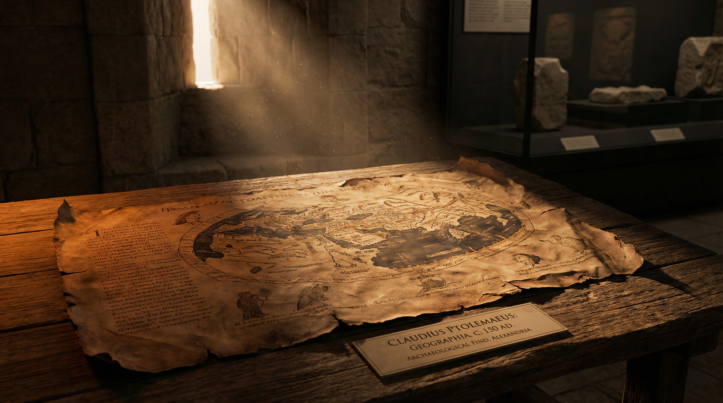
Ptolemy's Geography
6 min read
Last updated April 4, 2026
Claudius Ptolemy's 2nd-century atlas that mapped the known world with mathematical precision, introducing latitude and longitude coordinates that would not be improved for 1,400 years.
Choose your reading style:

By Marcus Hale
Independent Researcher & Archive Curator
Category: Maps & Geography
Civilization: Ancient Greek / Roman
Time Period: Ancient
Short Description: Claudius Ptolemy's 2nd-century atlas that mapped the known world with mathematical precision, introducing latitude and longitude coordinates that would not be improved for 1,400 years.
The World Unveiled: A 2nd-Century Cartographic Enigma
Imagine a world without Google Maps, without satellite imagery, without even reliable compasses. Now, imagine a scholar in the 2nd century CE, using nothing but astronomical observations, traveler accounts, and mathematical genius, creating an atlas so precise and comprehensive that it would guide explorers and cartographers for over a millennium. This is the enduring mystery and profound legacy of Claudius Ptolemy's Geography. More than just a collection of maps, it was a revolutionary treatise, a mathematical blueprint of the known world that laid the foundations for modern cartography. Its very existence challenges our assumptions about ancient knowledge, hinting at a vast network of information and intellectual prowess that continues to astound us today. How did a Roman-era Egyptian scholar achieve such an astonishing feat, and what secrets does his monumental work still hold?
Echoes from Alexandria: Historical Background and Rediscovery
Claudius Ptolemy, a polymath of unparalleled intellect, lived and worked in Alexandria, Egypt, during the 2nd century CE. A Greek-speaking citizen of the Roman Empire, Ptolemy was a mathematician, astronomer, astrologer, geographer, and music theorist. His Geography (Ancient Greek: Γεωγραφικὴ Ὑφήγησις, Geographikē Hyphēgēsis, or "Geographical Guidance") was not merely a set of maps, but an eight-volume treatise on how to construct them. The original work, likely penned around 150 CE, would have been written on papyrus scrolls, accompanied by detailed instructions for drawing the maps, rather than the maps themselves. The maps we see today are reconstructions, meticulously drawn by Byzantine and later European scholars based on Ptolemy's precise coordinates and projections.
For centuries, Ptolemy's work was largely lost to the Western world, preserved and studied primarily in the Islamic Golden Age. Arab scholars translated and expanded upon his work, integrating their own geographical knowledge. It was through these Arabic translations, and later Byzantine copies, that the Geography eventually made its way back to Europe during the late Middle Ages and early Renaissance. Its rediscovery in the 14th and 15th centuries sparked a cartographic revolution, providing a standardized, scientific framework for mapping that had been absent for over a thousand years. The earliest surviving manuscript maps date from the 13th century, but the most influential copies, complete with reconstructed maps, emerged in the 15th century, fundamentally reshaping European understanding of the world.
Technical Brilliance: The Latitude and Longitude Revolution
What makes Ptolemy's Geography truly remarkable is its rigorous mathematical approach. Ptolemy was the first to systematically apply a grid of latitude and longitude to map the entire known world. He defined latitude based on the length of the longest day, and longitude by measuring the time difference between various locations, often relying on astronomical events like lunar eclipses. While his prime meridian was set through the Fortunate Isles (Canary Islands), and his latitudes were measured from the equator, his methodology was groundbreaking.
The work comprises three main components: a theoretical introduction to mapmaking, a gazetteer of over 8,000 place names with their corresponding latitude and longitude coordinates, and instructions for constructing 26 regional maps and a single world map. The level of detail and precision for many locations, particularly within the Roman Empire, is astonishing for the era. He even proposed different map projections, acknowledging the distortions inherent in representing a spherical earth on a flat surface. This mathematical rigor, combined with his systematic compilation of geographical data, set a standard for scientific cartography that would remain unchallenged for 1,400 years.
The materials, originally papyrus, were later transferred to more durable vellum in the surviving manuscripts. These later copies, often richly illuminated, became prized possessions, reflecting the immense value placed on this ancient knowledge. The sheer scale of the undertaking, compiling thousands of data points from diverse sources, speaks to an organizational and intellectual capacity that far outstripped many later periods.
Whispers of Distant Lands: Competing Theories and Scholarly Debate
While Ptolemy's precision for the Mediterranean and parts of Europe is impressive, his mapping of more distant regions, such as Southeast Asia and East Africa, presents a fascinating enigma. His inclusion of places like "Sinae" (China) and "Thina" (perhaps Hanoi or a region in Vietnam), along with detailed coastlines and rivers in what we now know as the Indian Ocean, suggests access to a wealth of information from long-distance trade routes. These details often predate surviving written accounts of such voyages from the Roman world.
Scholars debate the exact nature of Ptolemy's sources. Did he have access to lost Greek or Roman peripli (sailors' logs)? Was he compiling information from Indian, Persian, or even Chinese traders who had reached Alexandria? The accuracy of some of these far-flung locations, despite significant distortions in overall scale (such as the exaggerated size of Asia), points to a sophisticated network of intelligence gathering that has largely vanished from the historical record. The "Golden Chersonese" (Malay Peninsula) and the "Great Gulf" (Gulf of Thailand) are depicted with surprising detail, implying direct or indirect knowledge that is difficult to reconcile with the conventional understanding of Roman geographical reach.
Another area of debate concerns the "Ptolemaic error" – his underestimation of the Earth's circumference and the exaggerated eastward extent of Asia. This error, while seemingly a flaw, had profound consequences. It made the westward journey from Europe to Asia appear much shorter than it actually was, a miscalculation that famously emboldened Christopher Columbus to attempt his transatlantic voyage in 1492. Columbus, possessing a copy of Ptolemy's Geography, believed he was sailing to the East Indies, not an entirely new continent.
Challenging the Narrative: Ancient Knowledge and Global Connections
Ptolemy's Geography fundamentally challenges the conventional historical narrative of isolated ancient civilizations. It demonstrates a level of global awareness and interconnectedness in the 2nd century CE that is often attributed only to later periods of exploration. The meticulous compilation of data from diverse sources, stretching from the Atlantic to the Pacific, suggests a sophisticated intellectual infrastructure dedicated to understanding the world.
The work underscores the importance of Alexandria as a hub of knowledge and trade, a melting pot where information from across the known world converged. It implies not just casual anecdotes from travelers, but potentially organized efforts to collect and synthesize geographical data, perhaps even official Roman surveys or detailed reports from merchants and navigators. The very existence of such a comprehensive work, with its mathematical underpinnings, forces us to reconsider the intellectual capabilities and global reach of the ancient world, revealing a period far more interconnected and scientifically advanced than often portrayed.
A Legacy Etched in Maps: Lasting Significance
The enduring significance of Ptolemy's Geography cannot be overstated. For over a millennium, it served as the authoritative text on world geography for both European and Islamic scholars. Its systematic use of latitude and longitude became the standard for cartography, a system that, with refinements, remains in use today. When the Renaissance brought a renewed interest in classical learning, Ptolemy's work was rediscovered and became the bedrock upon which the Age of Exploration was built.
Christopher Columbus's reliance on Ptolemy's calculations, despite their inaccuracies regarding Earth's circumference, directly led to the European discovery of the Americas. While his maps were eventually superseded by new discoveries, Ptolemy's methodological framework, his commitment to mathematical precision, and his ambitious attempt to map the entire known world laid the intellectual groundwork for all subsequent cartographic endeavors. His Geography is not merely an ancient artifact; it is a testament to human curiosity, intellectual ambition, and the enduring power of scientific inquiry to shape our understanding of the world, a power that resonated across continents and centuries, forever changing the course of history.
Marcus Hale
Independent Researcher & Archive Curator
Marcus Hale is an independent researcher and the curator of The Forbidden Archive. He has spent over a decade studying anomalous ancient technologies, cross-referencing primary excavation reports, museum catalogues, and peer-reviewed journals to document artifacts that mainstream history struggles to explain.
Competing Theories
Ptolemy's coordinates for some locations are remarkably accurate for the era. His mapping of Southeast Asia and East Africa suggests access to trade route information from sources that have not survived.
Archive Record
Civilization
Ancient Greek / Roman
Time Period
Ancient
Approximate Date
c. 150 AD
Origin
Alexandria, Egypt
Discovered
Byzantine manuscripts preserved in Constantinople
Current Location
Various libraries worldwide (manuscript copies)
Materials
Papyrus (original), later vellum manuscripts