Tang Dynasty China · Medieval
Dunhuang Astronomical Charts
4 min read
Last updated April 7, 2026
The Dunhuang Star Atlas is the world's oldest complete star atlas, mapping 1,339 stars across 13 charts with a precision that was not matched in European astronomy until the 18th century.
Also in This Category
Choose your reading style:
By Marcus Hale
Independent Researcher & Archive Curator
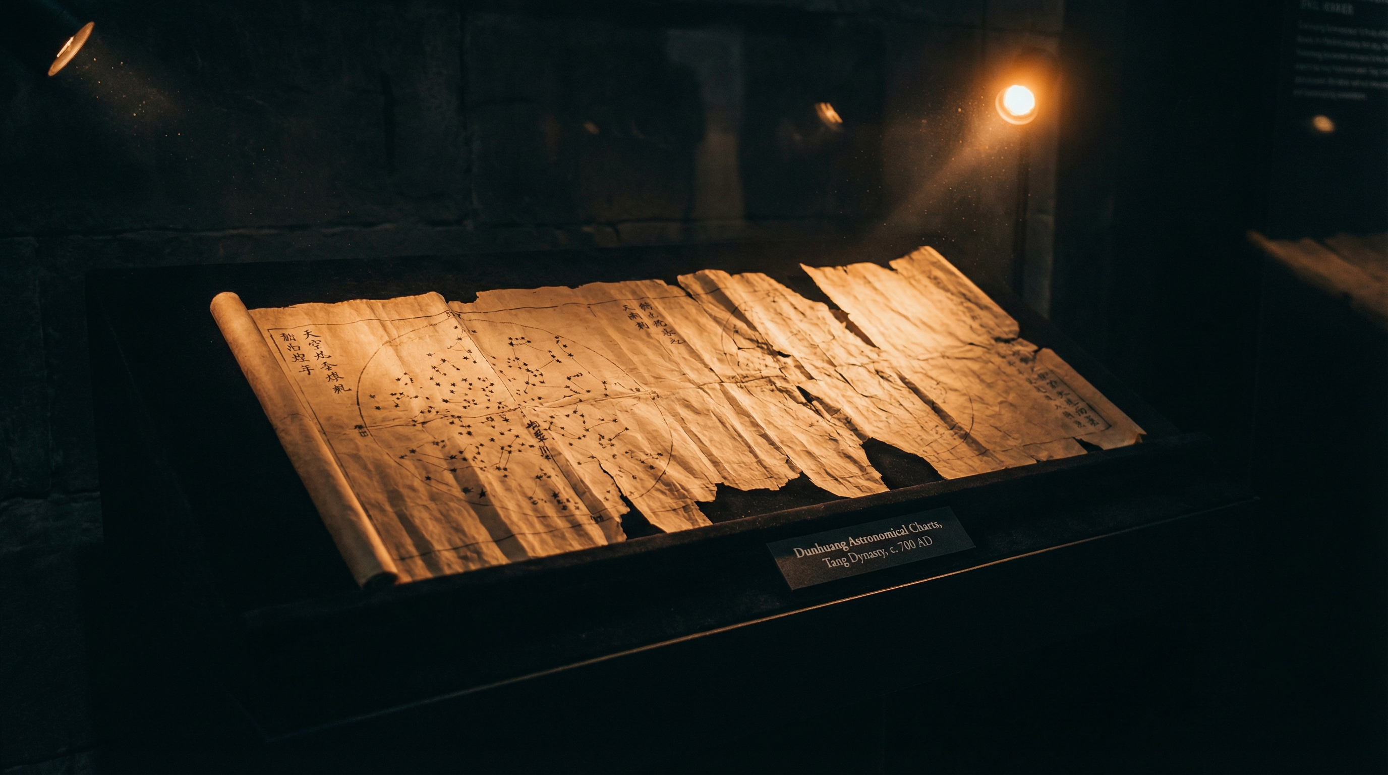
In 1900, a Daoist monk named Wang Yuanlu stumbled upon a hidden chamber in the Mogao Caves near Dunhuang, China. Behind a sealed wall lay a treasure trove of tens of thousands of manuscripts that had been untouched for nearly a millennium. Among these texts was a scroll, measuring roughly 210 centimeters in length, that would fundamentally alter our understanding of medieval science. Dating to approximately 649–684 CE during the Tang Dynasty, this document is now recognized as the world's oldest complete star atlas.
The 1900 Cave Library Revelation
The discovery of the Dunhuang Star Atlas happened almost by accident. The Mogao Caves, situated along the ancient Silk Road, served as a crucial intersection for trade and religious pilgrimage. When Wang Yuanlu cleared sand from Cave 16, he uncovered a hidden doorway leading to what is now known as Cave 17, or the "Library Cave." This small room contained manuscripts spanning centuries, preserving texts in Chinese, Tibetan, Sanskrit, and other languages. The British-Hungarian archaeologist Aurel Stein purchased a large portion of these manuscripts in 1907, including the star atlas, which currently resides in the British Library in London.
For decades, the atlas sat relatively unexamined by historians of astronomy. It was not until the latter half of the 20th century that scholars fully grasped its significance. The scroll contains 13 individual charts mapping the celestial sphere, followed by a final chart depicting the north polar region. What stunned researchers was not just the age of the document, but the sheer volume of data it contained. A total of 1,339 stars are meticulously plotted across the charts, a level of comprehensive mapping that European astronomy would not match until the 18th century.
Precision Mapping on Paper
The mathematical sophistication required to create the Dunhuang Star Atlas points to an advanced understanding of celestial mechanics. The creators employed a cylindrical projection to map the curved surface of the sky onto a flat piece of paper. This mathematical technique implies a deep grasp of spherical geometry. The 13 charts divide the sky into regions corresponding to the traditional Chinese lunar mansions, or xiu. The final polar chart uses an azimuthal projection, effectively combining two different mathematical approaches to represent the heavens accurately.
Analysis of the star positions reveals an astonishing level of accuracy. Researchers have determined that the positions of the stars plotted on the atlas are accurate to within 1.5 degrees. This precision is particularly impressive considering the tools available in the 7th century. The stars are drawn as small circles, with some colored in red, black, or white, possibly indicating different astronomical traditions or the specific astronomers who originally cataloged them, such as Shi Shen, Gan De, and Wu Xian. The text accompanying the charts provides additional astronomical and astrological data, linking the celestial movements to terrestrial events.
Cross-Cultural Exchange on the Silk Road
The geographical location of Dunhuang on the Silk Road raises intriguing questions about the flow of scientific knowledge in the ancient world. The mathematical techniques used in the atlas suggest the possibility of cross-cultural exchange. While the core astronomical tradition is undeniably Chinese, the level of mathematical sophistication has led some scholars to investigate potential influences from Babylonian or Indian astronomy, which could have traveled along the trade routes.
The Tang Dynasty was a period of cosmopolitanism and intellectual curiosity. The imperial court employed astronomers from various backgrounds, including those of Indian descent, to manage the calendar and interpret celestial phenomena. The Dunhuang Star Atlas might represent a synthesis of these diverse astronomical traditions, a physical artifact of the intellectual networks that spanned Eurasia. The scroll itself, made of fine paper, is a product of advanced Chinese papermaking technology, providing a durable medium for this complex scientific data.
The Legacy of the Tang Astronomers
The Dunhuang Star Atlas forces a reevaluation of the timeline of scientific progress. For many years, the narrative of astronomical history focused heavily on Greek and later European achievements. The existence of this highly accurate, mathematically sophisticated star map from 7th-century China demonstrates that advanced scientific practices were flourishing in East Asia long before the Renaissance in Europe.
The atlas also highlights the dual nature of astronomy in ancient China. While the mapping of the stars was a rigorous scientific endeavor requiring precise observation and mathematics, its ultimate purpose was often astrological. The movements of the stars were believed to mirror the affairs of the state, and accurate celestial maps were essential for the emperor to maintain the Mandate of Heaven. The Dunhuang Star Atlas, therefore, is not just a scientific document, but a political and cultural one as well, offering a window into the worldview of the Tang Dynasty.
How much of our current understanding of the cosmos is built upon forgotten observations made by anonymous scholars watching the night sky from the edge of the Gobi Desert?

Marcus Hale
Independent Researcher & Archive Curator
Marcus Hale is an independent researcher and the curator of The Forbidden Archive. He has spent over a decade studying anomalous ancient technologies, cross-referencing primary excavation reports, museum catalogues, and peer-reviewed journals to document artifacts that mainstream history struggles to explain.
📖 Take the Archive With You
Enjoyed this mystery? The full ebook covers 50 Ancient Mysteries in depth — lost technologies, suppressed histories, and artifacts that shouldn't exist. 300+ pages, instant PDF download.
Competing Theories
The atlas was discovered in the Dunhuang cave library in 1900 alongside thousands of other manuscripts. Its mathematical sophistication suggests access to earlier astronomical traditions, possibly including Babylonian or Indian sources via the Silk Road.
Archive Record
Civilization
Tang Dynasty China
Time Period
Medieval
Approximate Date
c. 649–684 CE
Origin
Dunhuang, Gansu, China
Current Location
British Library, London
Materials
Paper